A regular character in the tired debate between science and religion (or more broadly ‘spirituality’) is the strawman that science disenchants. Despite the countless efforts of extraordinarily gifted science popularizers like Richard Feynman, Carl Sagan, Neil deGrasse Tyson and plenty others to burn that strawman, it has eternal life (click on the links for short gems of such efforts). A real pity, because just a bit of geology-based knowledge can do so much to enchant what would otherwise remain an unremarkable Eindhoven region landscape.
At least it does for me. Similar to the bombshell impact of the famous pale blue dot photograph of earth (taken from the Voyager 1 spacecraft in 1990), that instantly shifted one’s perspective on the familiar (however fleeting that shift may be – once experienced one can keep returning to it), an awareness of the depth of geological time radically alters my perception when I manage to bring it to bear. I’ve been fortunate to have walked bits of landscape where this was really easy because it was impossible to put down my feet without stepping on fossils, recognizable as such even to a nitwit like me. The Eindhoven region requires more cognitive work, more effort to flex one’s attentional muscle, as the past is not so directly visible here.
Reading guidance: quite some images in the below expose need to be seen in enlarged versions to be fully understandable. Sometimes clicking on the picture – when the caption indicates this – results in a larger and often interactive version opening in a separate browser tab. Otherwise: right-click on the image and open a copy in a separate browser tab. It is going to show you a larger and better readable version of the image embedded in the post.
geological ‘deep’ time blows my mind
Our small region’s current geography as the Dommel river watershed is the result of very recent events in geological time. However, various of its determining characteristics, about which more below, while still recent, have their origins in a world the map of which we wouldn’t recognize. We clever apes are notoriously bad at scales beyond what matters for our survival . So the enormity of geological time is quite literally incomprehensible to us. Try to get your head around the below:
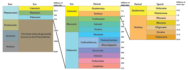
For a more detailed version by the official committee in charge of defining the eras nd periods, click here.
The Dommel river system is a small part of the river Meuse (Maas in Dutch) watershed, which is in turn is tightly coupled with that of its larger sister, the Rhine. Understanding the development of the Dommel river system requires understanding the story of those two larger rivers and that story is is in a very literal sense read from the earth, recent history on top, the axis of geological time pointing down. Beware, this is an oversimplification. Often old layers are exposed at the surface, because of all kinds of tectonic processes (which I’ll go into a bit below), erosion, etc. but in general deep is old, and surface is young.
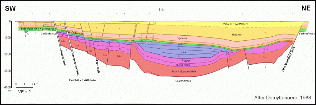
The below cross-section (from South West to North East) of the Dommel floodplain shows a subterraneous layering of rock and other deposits, and while the colour scheme doesn’t match that of the geological time diagram above, you can see – if you follow my advice to open a larger version in a new browser tab – that the older layers are below and the more recent layers on top. It also shows that a large part of the floodplain is a (so-called) rift valley that was created by the land between two ‘faults‘ (labelled Feltbiss and Peel boundary in the image) sliding downward and subsequently filled with way thicker versions of the layers to its left and right. Those layers and the rift valley are important characters in the Dommel river system story that I am going to tell. To the extent that this posts helps you make sense of this image it is not a total waste of time.
tectonic processes
Here we go: the way the Dommel watershed emerged has its origins in the Mesozoic (the age of dinosaurs) or even the Paleozoic. Apart from the unrecognizable animal and plant life of those days, our bit of land/seabed was located in a very different spot on the planet than it is now, somewhere close to the equator. The basics of why that was the case is explained in this short video:
And where ‘we’ were around hundreds of millions years ago, and how we got to were we are now is shown in this short animation, a hypnotic time lapse dance of moving earth crust. You may feel initially like having no clue what you are looking at, but please: hang in there. As soon as we get close to the present the fog will rise and when time is subsequently played in reverse you are going to be rewarded for your persistence:
Below an even shorter animation, centred on the UK, in which the two processes that matter most to our story are not too difficult to spot. This shorter slice of geological time shows the emergence of the last supercontinent Pangea and its subsequent breakup and dispersion into our current geography (plate tectonic enthusiasts love to speculate about the next supercontinent, Pangea Proxima, which, based on the supercontinent cycle, might emerge within the next 300 million years). Notice that what is going to become the Netherlands at the start of the animation begins its journey near the South pole.
In case you are looking for a visualization starting from the beginning of our planet, and including more than just plate tectonics, click here. Be warned, the information density makes for trippy experience. To absorb its story, several viewings are called for, and even then…but if enchantment is your goal, go for it!
some poetic music to accompany your reading
From now onward, no more videos, but lots of condense text, plentiful and confusing geological terminology, many visualisations that require some patient pondering. All in the hope that the fiercely complex story may blow your mind and make a difference when you wander about the Eindhoven region. A bold and most probably foolish hope, so to ensure you get at least something good from giving my bricolage a try, I offer some poetic background sounds to accompany your reading: the nearly two decades old debut album of a remarkable Dutch artist.
the formation of Pangea and the orogeny of the old mountain range hugging the the Dutch delta
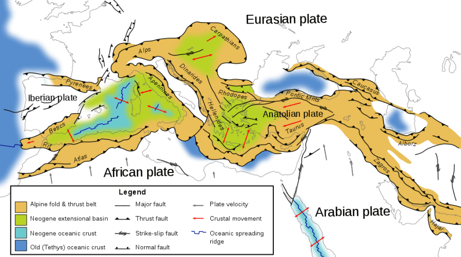
OK, back on topic: The Low Lands are a delta at the feet of the highland areas/low mountain ranges of the Ardennes and Eiffel and the rest of the larger Rhenish (or Rhine) massif. A lot of that delta was created by the Rhine river and its tributaries. The Rhenish massif hugging that delta is, in turn, part of the ‘old’ (deep time) country’ of the Rhenohercynian Basin – note, also named after the Rhine. This Basin was created by a mountain building process – something geologists call orogeny – resulting from the collision, 350-280 million years ago, of two continental constituents of the Pangea super continent (Laurasia and Gondwana) during its formation. You can see the collision happening in the video(s) above. The two image below show resulting tectonic fault zones and the mountain areas that were created.
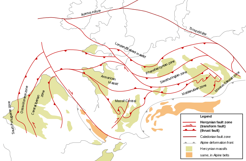
The old country plateau SOURCE: https://en.wikipedia.org/wiki/Rhenohercynian_Zone#/media/File:Hercynian_structures_Europe-en.svg By Woudloper – Eigenes Werk (own work) CLICK ON LINK FOR LARGER VERSION 
The mountain building process (orogeny) resulting from a paleocontinental collision SORCE: https://en.wikipedia.org/wiki/Variscan_orogeny#/media/File:Hercynides_EN.svg By Woudloper – Own work, CC BY-SA 1.0 CLICK ON LINK FOR LARGER VERSION
the creation of coal, salt, gas, oil: tectonics, temperatures and sea levels
What is now the Eindhoven ‘region’ is best thought of in elastic terms. One can make a good argument that what matters to the whole of The Netherlands also matters to understanding the region. That is e.g true when thinking about what kind of urban entity the city (region) of Eindhoven is, Equally, a lot of geological history is not visible when exploring the current Dommel watershed, but is nevertheless directly relevant to how the country and thus the region was build, powered, fed and made money, I’ll only share a smattering of the deep layer stratigraphy of the country. But keep in mind: without these ‘deep’ time resources, the Netherlands and thus Eindhoven region would have turned out quite differently.
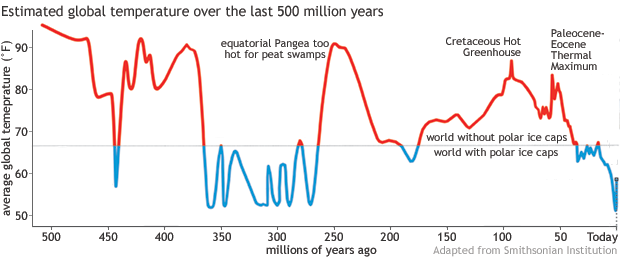
A deep time perspective brings the movement of tectonic plates into view, shown above, but also a succession of warmer and colder global temperatures, the accompanying sea level changes, and thus land being above or below the water. And all of the above (and more, a smattering I said…) in complex interactions, which include the residues of earlier life on earth, has concocted the stuff that we built our societies with: coal, gas, oil, chalk, salt, flint, sand and clay, and much more.
The images below visualise the global temperature and the global sea level fluctuations.
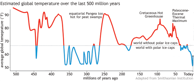

I’ll mention just a couple, that’ll give you a feel. This short journey takes us through only a slice of deep time, still incomprehensibly long, from the late Paleozoic to the mid Mesozoic. Note: geological eras represent the major stages in the macroscopic fossil record and are separated by catastrophic extinction boundaries. The end of the Paleozoic is marked by the biggest of them all. An interesting fun fact indeed for us sixth extinction competitors.
Anyways, Dutch coal, mined in Limburg, dates from a good 310 million years back (see above: the Pennsylvanian) and was formed from up to 40 meter thick layers of peat (248 on top of each other in total), remnants of the tropical mangrove forests that covered our land, then located near the equator. The layering was caused by cyclically rising sea levels that temporarily stopped peat formation and deposited sand and clay. During the next 100 million years (see above Permian and Triassic), the climate was more desert like, the land moved North to the current Canaries-Sahara region and was mostly submerged, and thick layers of salt were deposited. Another fun fact: in 2019 The Netherlands was the number one salt exporter worldwide by (value). The coal underneath the salt produces natural gas (and is therefore called its parent or substratum) that, blocked by the impermeable layer of salt, accumulates in the layers of sand stone immediately below the salt. The generous Dutch welfare state – by now substantially more austere – has largely been funded by the seemingly free money flowing into the treasury after the discovery of this natural gas in 1959. Ever heard of the Dutch disease? In 1977 the Economist made us quite famous arguing that our economic troubles in the 70s were evidence that the gas income came with unintended and quite serious economic consequences. We are also ‘cursed‘ with some oil, the substratum of which is Jurassic (marine) sediments called Posidonia Shale, deposited around 180 million years ago. I could go on, but if deep time hasn’t managed to dazzle you by now, the overkill by technical jargon will, so lets move on.
the breaking up of Pangea and the emergence of rift systems like the North Sea Basin
Back to our more circumscribed topic: Above I have described the creation of the Rhenish massif during the coalescence of Pangea. This massif was a precondition for the later delta-forming processes that created The Netherlands. A second ‘event’ shaping the delta formation was the breaking up of Pangea. The accompanying tectonic stresses, resulted in the emergence of various rift systems. The earth’s crust is torn apart, a fault emerges with one side of the crust sliding down. Often parallel running faults appear. The depression between two such fault lines is called slenk in Dutch geology jargon, or Graben in internationally used lingo. If several parallel depressions are created, the ridges in between are called horst (in Dutch). The North Sea basin started as a major component of the rifts developing from this breaking up, but turned into a so-called failed arm of the major extension which created the Northern Atlantic Ocean.
the Alpine orogeny makes for subsidence of the North Sea basin and the emergence of the Roerdalslenk
Later, from the end of the Mesozoic, the continued drifting apart of former Pangea constituents resulted in the collision of the African landmass with Europe, and the resulting mountain formations, the so-called Alpine orogeny, also made for tectonic stresses and the emergence of such rift systems. And it made for the gradual downward settling or subsidence of the North Sea basin, which made it, when not submerged by rising sea levels, even more of natural pathway for large river systems like that of the Rhine and the Eridanos (see below). For an interesting short video on the formation and stratigraphy of the European alps, see here.
The so-called Roerdalslenk, or Ruhr Graben, a 150k long and 25k wide depression and the ‘channel’ of the Dommel in Brabant, emerged from about 25 million years ago due to these Alpine orogeny stresses.. This particular Graben/slenk is part of the Lower Rhine Graben rift system, which in turn is part of the European Cenozoic rift system (ECRIS, between the Mediterranean and the Atlantic). Many rifts are not active anymore, but the Roerdalslenk still is and is thus still sinking. It is one of Europe’s most active tectonic structures that isn’t part of tectonic plate border.
The below images show (1) the mountain ranges resulting from the collision of Europe and Africa, (2) the depth of sedimentation deposits that cover the floor of the North Sea Basin, (3) a diagram visualising rifting earth crust and the resulting faults, horst and Graben, and (4) the location of the Roerdalslenk and the Ardennes-Eiffel.
Alpinine orogeny SOURCE: https://en.wikipedia.org/wiki/Alpine_orogeny#/media/File:Tectonic_map_Mediterranean_EN.svgBy Woudloper – Own work, CC BY-SA 1.0 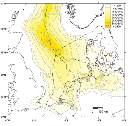
North Se Basin, Thickness of Cenozoic sediments SOURCE: https://www.geologienederland.nl/files/ftp/1-2-3%20Geologie%20Definitief.pdf (p.29) 
SOURCE: https://www.dov.vlaanderen.be/sites/default/files/pfiles_files/H3Ogeologische%252520verkenningRoerdalslenk_Michiel%252520Dusar.pdf (slide 9) 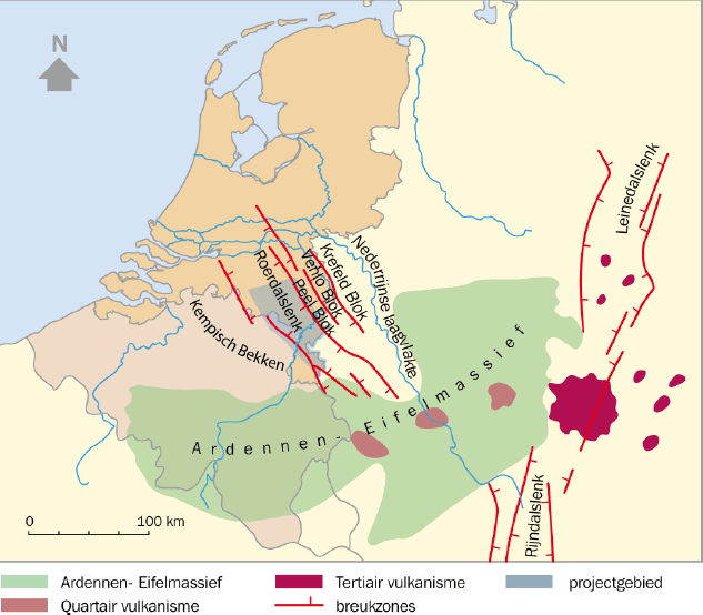
Location of the Roerdalslenk. SOURCE: https://geoera.eu/blog/timing-is-everything/
the Quaternary, the big rivers, sedimentation, and the formation of the Dutch delta
The processes of sinking slices of crust and subsidence of basins created ever deepening depressions. This was counterbalanced by sedimentation. For a large period these were all marine (sea) deposits. During most of the Miocene (see graphic above: 23 – 5+ million years ago) nearly all of The Netherlands was under the sea (thus whale etc. fossils etc. that can be seen in some museums), but the climate cooled toward the current era of ice ages, the so-called Quaternary (or pleistocene, terminology…sigh…) glaciation, starting 2.5 million years ago.
The Quaternary glaciation consisted of a succession of cold glacial periods, with extending and warmer interglacials with retreating ice sheets. During those glacial periods, the North Sea level dropped up to 120 meters and most of it became dry land. This is when The Netherlands (re-)emerged from the sea, and now the importance of the Roerdalslenk for what happens next becomes more evident.
Intermezzo: The names used for the various glacial/interglacial periods of the Quaternary glaciation vary across the globe. Professionals now mostly use a technical number system, but the traditional/historic names still dominate popular science explanations and yours truly has chosen to bricolage this post together without trying to translate all terminological confusion away. Please don’t judge too harshly.
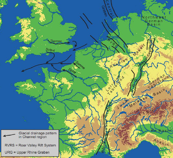
The European Cenozoic rift valley system – that the Roerdalslenk was a part of – influenced the trajectories of major rivers, and those, in turn, played a huge role in where they deposited their (so-called fluvial) sediments. With this rift system as a co-determinant of flow channels, the precursors of the Rhine and Meuse (note: the Waal is basically the Rhine’s main distributary branch after the river enters the country), helped by glacial outwash, sculpted the Dutch delta. And within that overall delta formation, the constituent Dommel river system, during the later parts of this history, sculpted the Eindhoven region. The Rhine is big brother among the rivers that created the Netherlands, and lots of the country is built on its sediments. Well actually, there is another big brother, an ice age era river called Eridanos , draining the current Baltic sea region, that deposited a lot of the sediments making for the North Eastern part of the country. Before the disappearance of this mega river, the way smaller Rhine-Meuse system was only a tributary sidekick river. Further below are images showing this all in more detail).
But first: below images of (1) ECRIS, and (2) The Roerdalslenk and parallel faults, and the contiguous West Netherlands Basin, which continues this rift system into the North Sea Basin of which it is the South Eastern most part.
European Cenozoic Rift System (ECRIS) SOURCE: https://www.dinoloket.nl/sites/default/files/file/dinoloket_h3odownloads_20140724_h3ogeologische_verkenningroerdalslenk_michiel_dusar.pdf (slide 13) 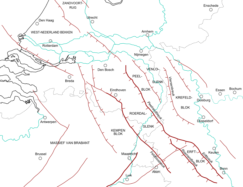
SOURCE: Reordalslenk connects to West Netherlands Basin https://nl.wikipedia.org/wiki/Roerdalslenk#/media/Bestand:Roerdal_graben_map_NL.svg Door Woudloper – Eigen werk, CC BY-SA 1.0
the course of the big rivers and glacial and interglacial periods
As you can see from the the map above the Rift system extends into the the North Sea in a North Western direction and the the Rhine originally flowed into the sea somewhere East of Scotland. But during the so-called Anglian glaciation, also known as the Elster glaciation (terminology battles….sigh…) – approx. 450.000 years ago, see the image below – the northern part of the present North Sea was blocked by the ice and a large lake developed, that overflowed through the English Channel. This caused the Rhine’s course to be diverted through the English Channel. Since then, during glacial times, the river mouth was located offshore of Brest, France and rivers, like the River Thames and the Seine, became tributaries to the Rhine. During interglacials, …sea level rose to approximately the present level. (Rhine-wikipedia). Also the Scheldt (Schelde) and Meuse (Maas) were tributaries. The quite literal sense in which the Rhine and its tributaries, especially the Meuse, have given birth to my country is awesome. And the way they connect a lot of North-Western Europe into one territory even more so.
The images below show (1) how much of North West Europe is part of the Rhine-Meuse watershed, and how much of the Netherlands is its delta, (2) the furthest reach of the Elster glaciation that forced the Rhine-Meuse into a different course, and (3) the furthest reaches of the subsequent Saale and Weichsel glaciations.
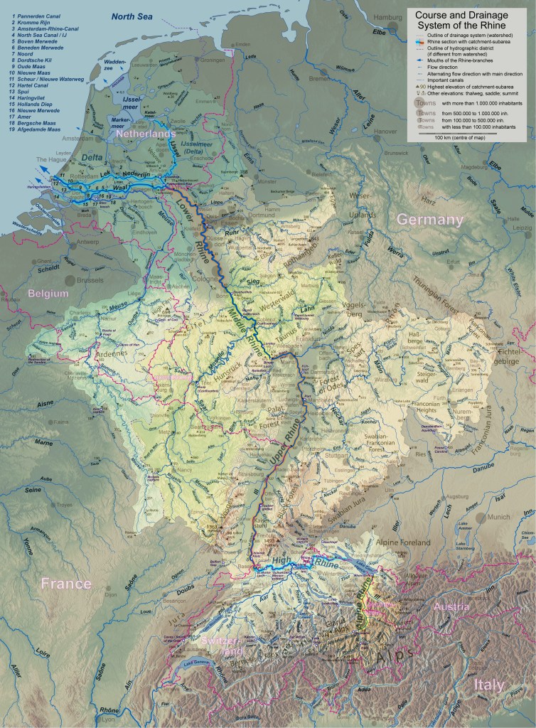
https://upload.wikimedia.org/wikipedia/commons/d/dc/Flusssystemkarte_Rhein_04.jpg RIGHT CLICK ON IMAGE FOR ENLARGED VERSION 
Furtest reach of the Elster glaciation forcing the Rhine Southward into the Atlantic. SOURCE: https://en.wikipedia.org/wiki/Elster_glaciation#/media/File:Largest_Glaciation_on_Europe.svg By Merikanto – Own work, CC BY-SA 3.0, https://commons.wikimedia.org/w/index.php?curid=17085729 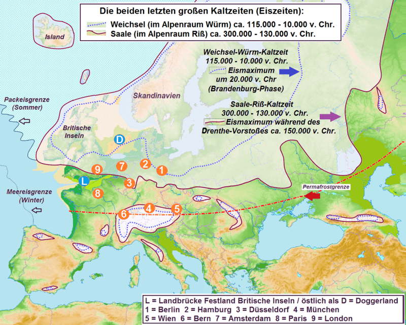
Extent of the two last glacial periods, the Saale and Weichsel SOURCE: https://en.wikipedia.org/wiki/Saale_glaciation#/media/File:SaaleWeichsel_x.png ; By Juschki – Own work This file was derived from: Europe topography map.png
the last two glacial periods (Saale and Weichsel) matter most for the landscape we see today
Most relevant for our story- in the sense of creating the foundations of the landscape we can actually see today– are the last two glacial periods, the Saale glaciation and the Weichsel glaciation, and the Eemian interglacial in between (note: each glacial period, when looked at more closely is actually a succession of colder and warmer periods – nature sure loves its fractals, but lets stay focused). During the Saale, half of The Netherlands was covered by ice, during the last Weichsel period the ice didn’t reach as far South but the country was a frozen tundra (see image above).
These glacial advances and retreats, their outwash, and their effects on the course of the big rivers traversing The Netherlands to their mouths, the sedimentation deposits of those big rivers, in combination with other effects of the weather (temperature, precipitation, wind), i.e. other than glacial advances/retreats alone, were the major determinants shaping the landscapes that we can still see now.
but to understand the Campine plateau where the Dommel originates we need to go back one glacial period (Elster)earlier
The origins of the Dommel river system is the plateau (high plane) of Campine, a natural region of Northern Belgium and South East Brabant. The plateau is like a flat-top hill with some of the streams that have their source there, like the Bosbeek, Dommel, Beerze etc. being part of the Meuse watershed, while others join the Scheldt. The plateau is scree from the Ardennes and beyond deposited by the Rhine and Meuse. A lot of debris was already deposited during the earlier mentioned Elster glaciation. During the one before last glaciation (Saale) the ice sheet reached half way down the current Netherlands (see picture above) and forced Rhine and Meuse to again change course Westward. The wall of ice also slowed the flow speed and made for increased sedimentation. Quick and dirty: without Rhine-Meuse deposits, no plateau, without plateau, no Dommel.
The below images show (1) the whole plateau of fluvial sediment North of the Ardennes that the Campine plateau is a part of , and (2) the Campine (Kempisch) plateau proper, where our protagonist, the Dommel, originates (near Peer).
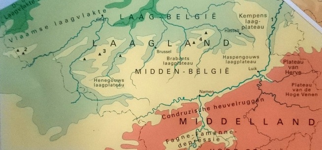
The Campine plateau, part of a large sedimentation deposit North of the Ardennes SOURCE: https://hetvrijeveldvanessa.weebly.com/fysische-omstandigheden.html# 
The Campine Plateau a closer look. The Dommel source is near Peer. SOURCE: https://nl.wikipedia.org/wiki/Kempens_Plateau#/media/Bestand:Kempensplateau.jpg
a closer look at the delta formation by sedimentation during the Quaternary
Before we move on to our current geological period, the Holocene, during which the Dommel river system was created (well actually the one before last as we have recently, be it not yet officially codified, entered the anthropocene, but that is a different story), lets look at some more visualizations of the sedimentation process during the Quaternary, and especially during the more recent ice ages. The below shows the sedimentation of the North by the Eridanos (and a first deposition in the South by the Rhine-Meuse) during the Pretiglian and Tiglian, internationally now known as the Gelasian (2.5-1.8 million years ago), and then the Rhine and Meuse deposits of the Cromerian interglacial (more than 500.000 years ago) and finally the so-called aeolian (wind) deposits (more on those below) during the Elster glaciation (450.000 years ago) that forced the Rhine into a different course and its delta to offshore Northern France.
During the Holstein interglacial between the Elster (500.00-400.00 )and Saale glaciations (330.000-130000 years ago) the Rhine returned to the floodplain of the previous (Cromerian) interglacial,; the Saale glaciation forced the river again into Western direction like during the previous (Elster) glaciation. During the Eemian interglacial, it moved back into its interglacial floodplain again (leaving the glacial floodplain to the Meuse), and, finally, during the last Weichsel glaciation (115.000-11.700 years ago) the Rhine-Meuse river system settled on its current trajectories, although there was still lot of changing of channels within the floodplains going on, up until very recent historical times (a topic for another post), before the contemporary situation was finally established (more on some early shifting of channels below).
The colour scheme stands for the following:
| Blue = marine (sea) deposits | Red = glacial deposits |
| Green – Meuse deposits | Orange = Eridanus deposits |
| Beige = Rhine deposits | Grey = aeolian (wind) deposits |
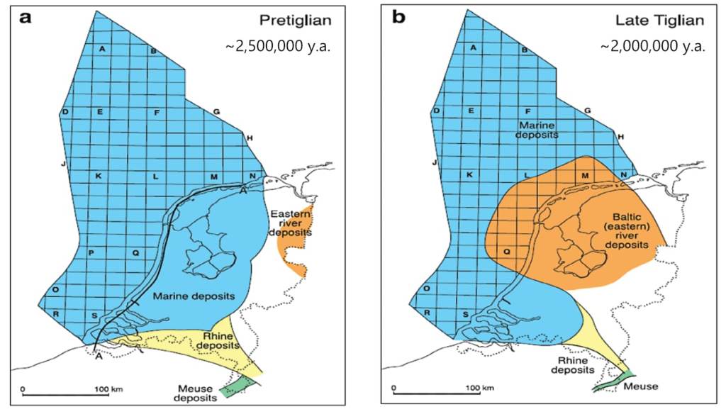
SOURCE: https://www.geologienederland.nl/files/ftp/1-2-3%20Geologie%20Definitief.pdf (p.44) 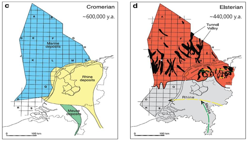
SOURCE: https://www.geologienederland.nl/files/ftp/1-2-3%20Geologie%20Definitief.pdf (p.44) 
SOURCE: https://www.geologienederland.nl/files/ftp/1-2-3%20Geologie%20Definitief.pdf (p.45) 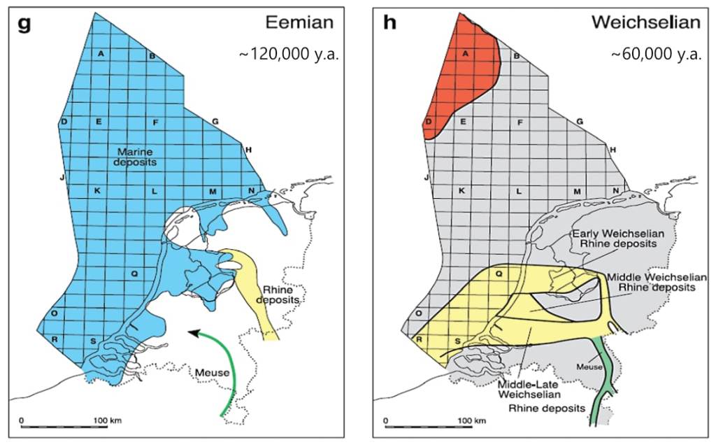
SOURCE: https://www.geologienederland.nl/files/ftp/1-2-3%20Geologie%20Definitief.pdf (p.45)
further zooming in on river sedimentation during glacial and interglacial periods
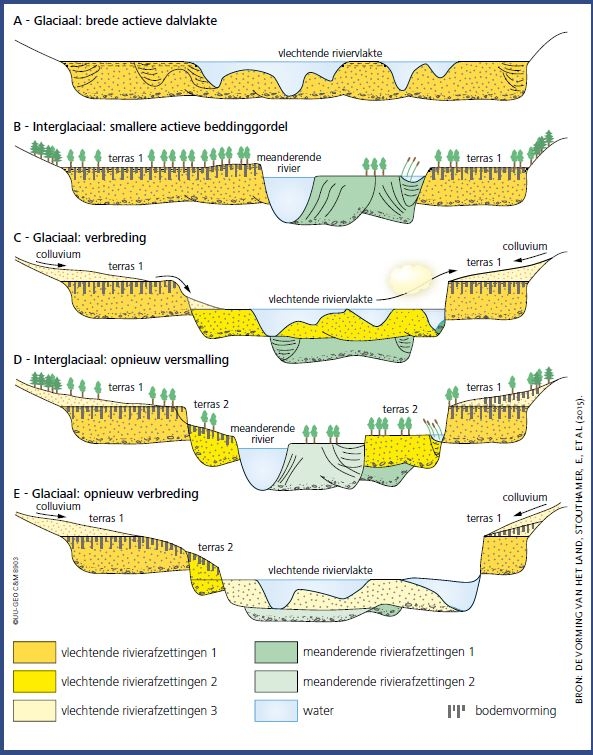
The river sedimentation process itself was a layer upon layer affair, determined by the channel pattern followed by the river, which in turn was determined by climate (glacial/interglacial) and other factors. The quick and dirty generalization is that the rivers were following a braided course during glacials and a meandering one during interglacials.
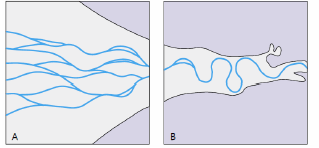
The below shows what the sedimentation process in a floodplain may have looked like. Braiding is vervlechtend in Dutch, deposits is afzettingen in Dutch.
wind relocation old marine and fluvial sediments landscapes the region during the current Holocene interglacial
I haven’t devoted attention to glacial sedimentation and other contributions of the ice sheets to the Dutch landscape other than mention their role in forcing the big rivers into alternative courses. And I will leave it at that as far as the ice itself is concerned because its visible heritage, e.g. the moraine remnants, are not visible in the Eindhoven region. I focus on another consequence of the glacial periods: the arctic temperatures that turned the land into frozen tundras with hardly any plants, let alone trees. This left the wind to deposit sand and clay from e.g. the centre of the North Sea Basin near its perimeter, the Dutch delta. These processes, At and after the end of the last (Weichsel) ice age have had a huge influence on the landscape as we see it now. The permafrost disappeared gradually, rivers like the Dommel started eating themselves into the land, the ground water level decreased, and the lack of a proper vegetation cover gave the wind free reign to play with the surface sands. Over a couple of thousands of years a lot of the country was covered in one to two meters of cover sand, including some elongated dunes (cover sand ridges) in a South Western-North Eastern direction of the then time prevailing winds. The below middle picture (click on image for a large version) shows how gradually the sea level rose during the Holocene.

the Dommel river system emerges, cover sand ridges, fens
The Dommel and its tributaries started as fast flowing melt water streams that dropped into the sinking Roerdalslenk, and sought their way to the Meuse. When the climate warmed they started to eat channels into the cover sand layer above the thawing tundra floor. Wind created two main cover sand ridges – the so-called Middle Brabant (Turnhout – Gemert) ridge and the Northern Brabant (Loon op Zand – Nuland – Herpen) ridge – and these forced various streams into new channels. Old channels that didn’t disappear under new layers of cover sand developed into fens like those near Oisterwijk and in the Kampina (for the aficionados: there are fens with other histories, e.g. the so-called pingo remnants, dating from the last – Weichsel – ice age, a couple of which can be found in our region: here and here, and one on the Strabrechtse Heide).
As fractal as always, also the Holocene‘s gradual warming followed a zig-zag curve of warmer and colder periods, each with their own effects on (ground) water levels, flora, and fauna. Roughly 9000-5000 years ago was a warm and wet period, making for the emergence of both large forests and peat.
geology set the stage, from now onward us busybodies play the game
From here onwards, the influence of early inhabitants of this area started to have an increasing influence on the landscape. The cutting of forests to create agricultural land, the subsequent degradation of that land, the human responses to that, etc., initiate the present wherein all landscapes in inhabited regions like The Netherlands were shaped by us wise and often not so wise apes. Obviously, geology created the playground, but the game from now on is ours and that story is for another post.
But the contours of that playground, and the various parameters it sets for what works well and what is problematic, despite thousands of years of human use whittling away at it, are still visible everywhere. The Dommel and its tributaries and the cover sand ridges and high grounds in between determined habitation locations and transport corridors. and all of that in turn was part of the larger playground of the Meuse watershed.
The below images (1) locate the Eindhoven region within the watershed of the Meuse, and (2) the river system with the current build-up areas, the locations of which, in different ways, are all determined by these streams.
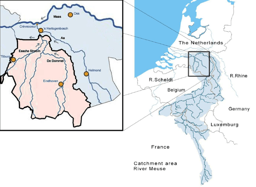
SOURCE: https://docplayer.nl/41148867-Analyse-van-de-effecten-van-maatregelen-in-het-stroomgebied-de-dommel-op-wateroverlast-rond-s-hertogenbosch.html (p.3) 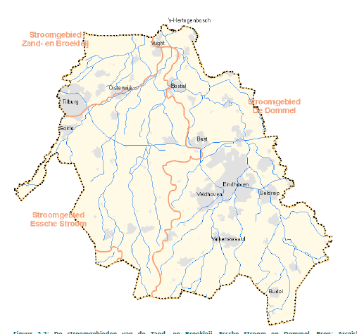
SOURCE:https://docplayer.nl/41148867-Analyse-van-de-effecten-van-maatregelen-in-het-stroomgebied-de-dommel-op-wateroverlast-rond-s-hertogenbosch.html (p.12)
the determining influence of Holocene sand ridges on habitation patterns
The determining influence on habitation patterns of the sand ridges and high grounds (in turn determined by a pre-existing layer of aeolian cover sand and clay) is very evident from the below. The first image shows the geomorphology of the area around Eindhoven with a focus on the Dommel and its many tributaries. The colour scheme is quite intuitive: yellow are sand ridges, green are river valleys, white are cover sand plains, brown are peat remnants. The old market centre of Eindhoven (more on that next) was build on the sand ridge labelled Hoogstraat in the lower part of the image. Until way into the 19th century, all habitation was concentrated on sand ridges or other high grounds.

the location of Eindhoven
To conclude, let’s zoom in even further and have a look at the development of the Eindhoven city centre. The original Eindhoven, derived its importance from its location on cover sand ridge where the Gender joins the Dommel, at the crossroads of two important transport routes: from Den Bosch to Liège (Luik) and from Antwerp to Germany. The below walks you through the market town’s early development.

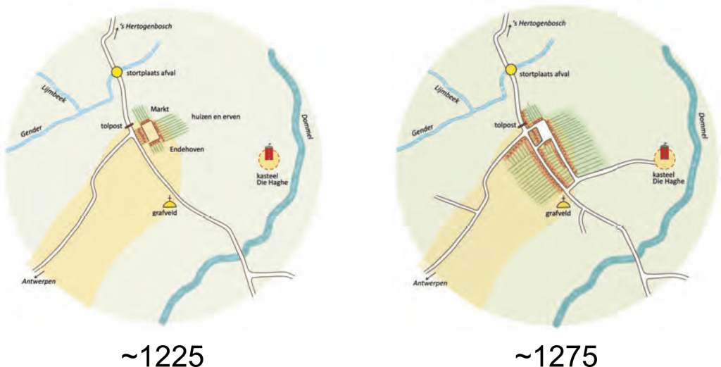
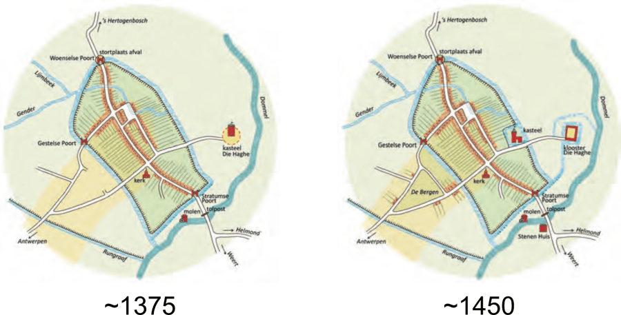
For a long time nothing much changed. Some of you may have seen the Jacob van Deventer map (around 1560) of Eyndhoven, but around 1830 the city was still pretty much the same, a small urban core with attached ribbon development along the trading routes. The ribbon along the Hoogstraat – the beginning of the Southern trade route toward Liège (Luik) – is still evident to anyone walking it, and on a municipal visualisation of when buildings were constructed (see below) it meanders as a thin red line on the ridge between the Gender and the Dommel from the Kleine Berg at the upper right toward the lower left. The Northern ribbon toward Den Bosch was mostly intact even as short ago as 1964, (just) before the post WWII Woensel extension of the city near totally eradicated the medieval street patterns in that part of town,
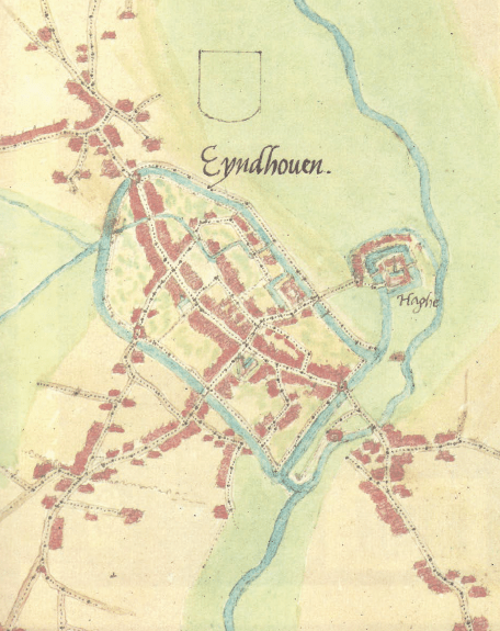
Eindhoven around 1560 SOURCE: https://pure.uvt.nl/ws/portalfiles/portal/39600565/Arts_Stad_23_06_2020.pdf (p.71) 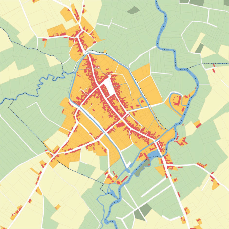
Eindhoven round 1830 SOURCE: https://pure.uvt.nl/ws/portalfiles/portal/39600565/Arts_Stad_23_06_2020.pdf (p.72) 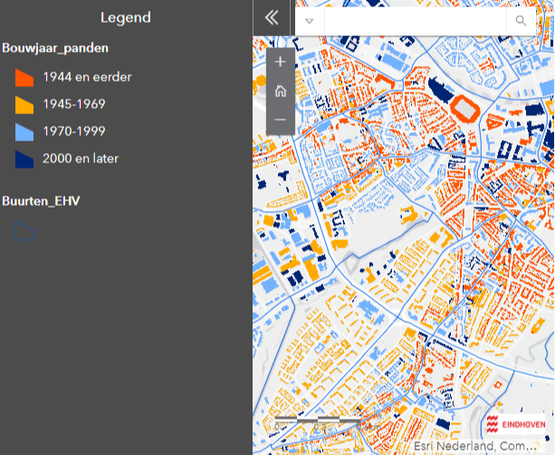
Hoogstraat ribbon development visualized using https://eindhoven.infogram.com/1prmgv0gn1yex2ag13ldxmdnjdh0j957n1 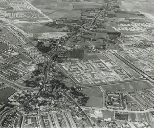
Woenselsestraat 1964 SOURCE: https://pure.uvt.nl/ws/portalfiles/portal/39600565/Arts_Stad_23_06_2020.pdf (p.52)
deep time is incomprehensible, but awesomely present
I hope that when you have made it all the way here, you understand why I made so much of the rift systems, and especially the Roerdalslenk, as natural river conduits, even though this “valley” now mostly seems an inconspicuous feature of the landscape. Why the stratigraphy of the slenk with its thick layers of marine, fluvial, glacial and aeolial deposits, that only reveal themselves when probed by the geologist’s toolbox, are worth knowing about. How come the top layer is all sand and clay, and what that meant for where us newcomers settled. Why deep time is beyond our ability to understand and still so very much present in our immediate environment. And why that blows my mind.
