This post is a lay person’s effort to understand what being a Dutch city means. And to understand how Eindhoven fits into that picture.
My interest in urbanism goes back some time, and is firmly rooted in my personal experience of expat living in places that urbanized very fast while I was living there and places that were a metropolis already. The Netherlands that I left decades ago, was thoroughly urbanized, but didn’t have even a single metropolis, at least not in the common usage sense of the word. In light of those formative experiences, what am I to make of my home country, extremely densely populated (in the top five of most populous countries), without any ‘real’ city?
The Netherlands, in particular the Western coastal region, has been the most urbanized bit of Europe since the Middle Ages (Dutch link). So urbanized in fact that farmers specialized early on to produce enough surplus to supply the coastal cities. And as that proved insufficient for the main staple the urban population survived on grain imported from the breadbaskets bordering the Baltic Sea. If one excludes city states, and other very small countries and countries wherein near everyone lives in one city, Belgium, Israel and The Netherlands are the world’s top three most urbanized nations. How come the Low Countries don’t feel like that, but rather more like a multitude of towns scattered about a rural landscape? The predictable answer is that to a large extent that is what they are: a garden city, or even better, using the Singapore branding slogan, a city in a garden (let’s ignore for the moment how polluted that garden is, a topic that deserves and will get a post of its own).

The Netherlands is still a green country, with more than four fifths of its surface area used for recreation, agriculture, woodlands and nature. Less than 15% of the country is red space (infrastructure, residential areas, building sites and other built-up areas).
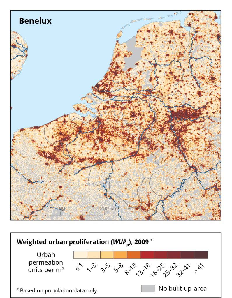
When one focuses on what that means for citizens, the above translates into nine out of ten inhabitants having access to green space (Dutch link), be it a park, green open space or forest, within 1 kilometer of their front door. The average distance to forest is 1.7 kilometers (map below, Dutch link), be it with considerable differences across the country. Both maps show that of the regions with a lot of expats, Eindhoven offers by far the greenest deal:

So one perspective on Dutch cities is that they are basically all part of one urbanized area (no, not urban area, that term has a technical meaning which doesn’t apply), or urban agglomeration, or conurbation, whatever your preference for terminology (the experts also disagree). Admittedly a very particular, maybe even one of its kind version: an urban agglomeration state. This perspective has a lot going for it because whatever the undeniable merits of recognizing the importance of sub and supra nation state networks as highlighted by the likes of Manuel Castells, Saskia Sassen, Parag Khanna, and many others, the determining influence of national institutions, bureaucracies, legislation, policy, traditions, path dependencies, etc., on everything within their borders is huge. Anyone who has crossed a couple of European borders – however big the impact of Schengen, the euro, and many other transnational arrangements may be – knows how viscerally different the world looks, feels, sounds, and tastes on either side of a national boundary. Interested in another view on this ‘Nethercity’? Have a look here.
Language is not the most powerful medium to transmit visceral difference, so let me illustrate with a pretty much random choice of Dutch, Belgian and German music that could never have emerged in another country:
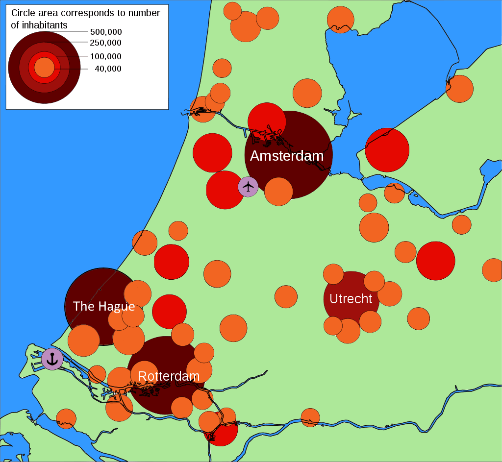
Valid as this urban agglomeration state perspective may be, it is not mainstream. For that one needs to scale down to smaller scale metropolitan areas. The Netherlands has only one internationally recognized specimen, of the polycentric kind, sometimes – wrongly in my opinion – labelled a megalopolis: the Randstad, consisting primarily of the four largest Dutch cities (Amsterdam, Rotterdam, The Hague and Utrecht) and their surrounding areas . But be warned, you’ll quickly notice that convincingly delimitating smaller scale entities within our urban conglomeration country is a difficult exercise.
That the Randstad in the 19th century didn’t follow the trajectory of other urbanized areas in Europe and develop into a ‘real’ metropolis has various reasons. A major one is that The Netherlands industrialized comparatively late, remaining a trading nation with its ports as the economic motor. When industrialization finally took off, it was in poor, rural sandy soil areas like our province Noord Brabant and Twente, which had abundant cheap labour.
With 8.2 million inhabitants (but see below!) the Randstad is one of Europe’s largest metropolitan areas, and without a peer of comparable size within Dutch borders. For peers one needs to cross borders: the more than five million inhabitants of the Belgian Flemish Diamant (consisting of the four agglomerations of Brussels, Ghent, Antwerp and Leuven and the area they enclose) and the more than ten million of the German Rhine-Ruhr metropolitan region.
The weird thing about the Randstad is that despite its internationally acknowledged status, at the national level the area doesn’t have any kind of talk shop, let alone coordinating body (other than the national government, with a one-off vision document about the region in 2008, mmm….underwhelming). What is and is not included under the umbrella of the term Randstad varies. The above mentioned 8.2 million inhabitants constitutes the widest interpretation, the original, way more limited definition including only the metropolitan areas of its four core cities would be maybe 4.5 million. There is an intermediate level (of the so-called Northern and Southern wings) that also lacks operational reality, but at least has a peer within Dutch borders: the approx. 2 million inhabitant ‘Zandstad’ (sand city) of the highly urbanized and industrialized province of North Brabant.

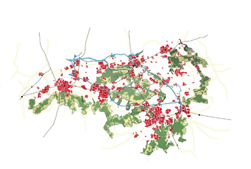
Within this larger Zandstad area, five city regions have formalized their collaboration into a network called Brabantstad, by some called a ‘mosaic’ metropolis, a ‘star nebula’ of settlements, a ‘global suburbia’, and one look at the map below shows why:
Zandstad/Brabantstad is so unique that it merits a short deep dive into what made for this distributed settlement pattern.
Brabant was staunchly catholic and its establishment was squarely opposed to the development of ‘sinful’, ‘atheist’ and ‘socialist’ densely packed metropolitan cities. I promise a lot more Eindhoven specific about this in a future post about its development as a company town. For now, what is important is the elite perspective on Brabant as an inherently rural and traditional area, inhabited by communities centred around their local church. When labour from elsewhere moved toward the new industrial centres, the elite understandably became an early adopter of Ebener Howard‘s garden city vision: creating new settlements, suburban villages, on cheap land in the vicinity of the city, separated by green spaces, a distributed kind of urbanization, rather than compacting inner cities to very high densities (the kind of metropolitan development of many industrial cities in e.g. the UK). The 1901 Law on Housing, aimed at improving the situation of urban slums, further supported the planned development of a global suburbia’ rather than compact ‘real’ cities.
This vision, despite various challenges over the course of the 20th century remained dominant until around 1965 because it was an identity buttress of the so-called catholic pillar. E.g. the post WWII development plan for Brabant formalized the ambition of a decentralized industrialization: the labourer was to remain in his ‘natural village’ environment and the job was to be brought to his doorstep – else his simple traditional soul would drown in the modern metropolitan cesspool. But even after the swift desecularization of Dutch society in the 60s and 70s, the vision of Brabant as a village society kept raising its head and determining spatial planning, resulting in a thoroughly urbanized rural landscape wherein every village has its own shopping centre and industry park, and is connected with other villages and the larger cities by a dense network of transport corridors. A mosaic, a nebula of stars, a global suburbia…
This has resulted in a pretty unique, thinly settled metropolis in which the urban and the rural are spatially, economically, and culturally tightly interwoven. This setup now needs planning for the future that isn’t caught up anymore in the phantasies of Brabant-as-a-village-society to make the most of its historically grown distributed settlement pattern in a garden. Will wisdom prevail? Who is is to say, but for the time being you may count yourself lucky to inhabit the greenest metropolis of the country, maybe even beyond.
A metropolis with its own anthem at that:
Back to my topic proper: one needs to scale down one more level, to that of core or twin-city centred metropolitan areas such as those making up the the least inclusive understanding of the polycentric Randstad agglomeration – Amsterdam, Rotterdam-The Hague, and Utrecht, for several somewhat comparable city regions to appear within the country. Now the Eindhoven metropolitan area, also known as Brainport, enters the picture, as one of several, or even quite a few non-Randstad urban regions, depending on who is talking.
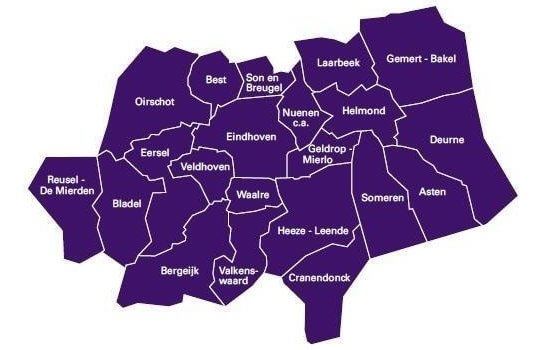
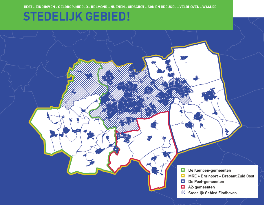
The story would become even more convoluted were I to try enlightening you about those many other Dutch city regions having a claim on that sort of metropolitan area label. So from here onward I focus on Eindhoven. The above depicted formalized collaborative arrangement with 21 conjoined municipalities is an important, but by far not the only perspective of what Eindhoven municipality is at the centre or part of.
A subset of nine of the collaborating municipalities present themselves as the urban core of the area and the heart of brainport and have a separate collaborative network called Stedelijk Gebied Eindhoven (urban area Eindhoven) with its own agenda.
Like all ambitious larger Dutch cities, the core city of Eindhoven, or one (or several) of its city defining institutions teams up in various other more or less formal collaborations . But these networks have normally a narrow focus (research collaboration, design and innovation initiatives, etc.) and it would be overdoing it to include these in a post of what characterizes a Dutch city in more general terms. What does merit mention though are:
- the existence of a mishmash of hierarchically, geographically, organizationally, and functionally diverse stakeholder networks of which the city is, often has to be (national level regulation stipulates it) a member, and that govern most that is of importance to the the lives of the city’s residents. Think everything to do with safety and security, lots of social work, education, but also energy, water and more.
- the relative lack of decisive control of the city (although Eindhoven being the core city it is the big brother member in quite a few networks ) over some sectors that set the determining parameters for how it can develop itself. Think public transport infrastructure, social housing policy, management/development of the agricultural and nature areas not within its municipal boundaries, etc.
Don’t get me wrong, this system of multi-stakeholder, collaborative distributed policy development and implementation has definite advantages, not the least of which is that it ensures a broad support base for many decisions, and is a barrier against radical changes. One metaphor for this kind of governance is that it moves like a tanker. To get it to change direction takes a lot of time, and proceeds incrementally. Even after four decades of ‘neoliberal‘, ‘managerialist‘ policy conceptions we still have a comparatively commendable public transport system, we still have a public housing sector with affordable rents, we still have livable unemployment benefits, etc. Having said that, anything important of importance that really and urgently needs change, even when there is broad support for it, moves equally slow.
Sorry, I’m starting to move off topic here. What matters is that when envisioning the city of Eindhoven you have to think at least the urban area Eindhoven, better still the Eindhoven metropolitan area, embedded within an even larger urban agglomeration (Brabantstad or Zandstad, take your pick) which might not be the most densely urbanized region of the country, but is the one with the most evenly distributed population across a multitude of smaller scale but highly networked townscapes, a mosaic of urban locales in a rural setting. And for many purposes it makes sense to consider yourself the resident of a distinctive neighborhood of Nethercity, not a city with country status like Singapore, but a green country that is also an urban agglomeration.
Let me conclude with the unofficial national anthem of this Nethercity, appropriately for the kind of city-country we are it was (1996) written for a commercial of a privatised former state bank.
Updated 14-12-2020, with many thanks to René Erven (Architectuurcentrum Eindhoven) for input.
What is the Eindhoven/Brainport region series
- Post 1: Eindhoven as a Dutch city
- Post 2: what is my backyard
- Post 3: brainport’s real highlights

5 thoughts on “Eindhoven as a Dutch city”